

Customize
Customizing the portal
To customize the portal for a new country, you need to create a new directory, with the structure depicted below.
$PORTAL_CONFIG_DIR/
   ├── messages/
   │   ├── messages.properties
   │   ├── messages_en.properties
   │   └── messages_es.properties
   ├── layers.json
   ├── header.tpl
   ├── footer.tpl
   ├── portal.properties
   └── www/
       ├── unredd.css
       ├── custom.js
       ├── img/
       │   ├── banner_bg.jpg
       │   ├── flag.png
       │   ├── logos.jpg
       │   └── ui-elements.png
       └── loc/
           ├── en/
           │   └── [...]
           └── es/
               └── [...]
An example directory is shipped with the portal application, under WEB-INF/default_config. Use it as an example to build your own configuration directory.
The configuration directory contains the following files:
- Messages folder
messages/. - Layers definitions
layers.json. - Header and footer templates
*.tpl. - Portal properties file.
- A collection of static resources,``web/
. Two of the files are mandatory:
* ``unredd.css
, with portal styles. *custom.js, with custom javascript functionality.
The remaining files under web directory (images img and localized files loc) are referred from templates and layers configuration, and can be organized freely under www.
The portal properties file
The file portal.properties contains some important parameters, such as the geostore location, or the WPS custom stats service.
Please review its contents so the parameters match the server setup.
These are the mandatory properties:
- languages The languages to be displayed in the Portal interface. Make sure the corresponding localization file exists in the messages folder.
- geostore.url The REST endpoint of the dissemination geostore.
- geostore.username Dissemination GeoStore admin username.
- geostore.password Dissemination GeoStore admin password.
- recaptcha.publickey Needed to prevent robots send feedback and custom stats requests.
- recaptcha.privatekey Ídem.
And these are optional properties for the realtime stats. If not set, a default value will be used:
- stats.url: The WPS service base URL. Usually placed in the dissemination GeoServer. Defaults to http://localhost:8080/geoserver/wps
- stats.concurrency: The number of simultaneous WPS requests to be launched in parallel. Should be in accordance with the GeoServer server’s capabilities (a reasonable value is 2 * number of cores in the server). Defaluts to 4.
- stats.processname: The process name to be executed. Defaults to gs:OnlineStatsWPS.
An example portal.properties file:
languages = {"en": "English", "fr": "Français", "es": "Español"}
geostore.url = http://demo1.geo-solutions.it/diss_geostore/rest
geostore.username = admin
geostore.password = XXXXXX
stats.url = http://demo1.geo-solutions.it/diss_geoserver/wps
stats.concurrency = 8
recaptcha.publickey = XXXXXXXXXXXXXXXXXXXXXXXXXXXXXXXXXXXXXXXX
recaptcha.privatekey = XXXXXXXXXXXXXXXXXXXXXXXXXXXXXXXXXXXXXXXX
Translating the application
File names must be placed under $PORTAL_CONFIG_DIR/messages, and named messages_<language_code>.properties.
They contain localized string that are used to dynamically translate portal contents,
through Spring MVC framework, to get the localized text depending on the user’s selected language.
They contain key = value pairs, where key is the unique identifier of the localized text, and value is the actual translation (see example below)
title = Système National de Surveillance des Forêts de la RDC
subtitle = Ministère de l’Environnement, Conservation de la Nature et Tourisme
layers = Couches
redd_plus_activities = Activités REDD+
redd_plus_activity = Activité REDD+
deforestation = Déforestation (perte brute)
degradation = Dégradation de la forêt
enhancement = Accroissement des stocks de carbone
conservation = Conservation
sustainable_management = Gestion durable
The files that make use of the message files are:
header.tplandfooter.tpl- the portal header and footer templates.layers.json- used to define the layers and its rendering.
To refer to the localized string from these files, add a replacement tag of the form ${...}, like in the example below:
<span id="title">${title}</span>
Page design
The page design is defined in unredd.css. This file defines the layout of the portal.
It should be used to customize colors, banner, and adjusting sized of objects.
For example to adjust the size and offset of the flag and logos images in the header.
For the logos element in the header template, we can set a background image, and its position an size using CSS syntax:
#logos
{
  background: url(custom/img/logos.png) no-repeat 0 0;
  position: absolute;
  top: 19px;
  right: 20px;
  height: 55px;
  width: 130px;
  z-index: 1100;
}
Images and other static resources
Note that in the previous example, the image URL is static/img/logos.png.
All the resources starting with static/ correspond to the static/ directory on portal config dir.
So, for the logo image, it has to be placed under $PORTAL_CONFIG_DIR/static/img/logos.png.
Custom javascript
Some custom portal actions have to be defined as javascript functions.
Place them in :file:static/custom.js. For example, to set the base
URLs for the WMS layers:
UNREDD.wmsServers = [
   "http://localhost",
   "http://127.0.0.1"
];
And to link click events to specific statistics:
drc_provinces: function(feature) {
   var that = {};
   that.title = function() {
       return UNREDD.langData.province + ": " + feature.attributes.PROVINCE;
   };
   that.statsLink = function() {
       return '/stg_geostore/rest/misc/category/name/ChartData/resource/name/deforestation_script_' +  feature.attributes.OBJECTID + '_' + languageCode + '/data?name=' + feature.attributes.PROVINCE;
   };

   return that;
}
Layer definition
The file layers.json is in the root of the custom directory.
It contains the information to associate user interface elements (layer list pane on the left side of the page) to the WMS layers provided by GeoServer, and customize legends, online legends thumbnails, and identify which layers can be queried. It also allows to group layers into a three levels tree.
This is a sample layers.jon file:
{
  "layers": [
    {
      "id": "blueMarble",
      "baseUrl": "/geoserver_drc/gwc/service/wms",
      "wmsName": "unredd:world_topo_bathy",
      "imageFormat": "image/jpeg",
      "visible": true
    },{
      "id": "landsat",
      "baseUrl": "http://unredd.geo-solutions.it:9080/geoserver/wms",
      "wmsName": "unredd:training_background",
      "imageFormat": "image/png",
      "visible": true
    },{
      "id": "forestClassification",
      "label": "${forest_mask}",
      "baseUrl": "http://unredd.geo-solutions.it:9080/geoserver/wms",
      "wmsName": "unredd:training_mask",
      "imageFormat": "image/png8",
      "visible": true,
      "legend": "training_mask.png"
    },{
      "id": "administrativeUnits",
      "baseUrl": "http://unredd.geo-solutions.it:9080/geoserver/wms",
      "wmsName": "unredd:admin_local_level_governance_upng",
      "imageFormat": "image/png",
      "visible": true
    }
  ],

  "contexts": [
    {
      "id": "blueMarble",
      "active": true,
      "label": "${blue_marble}",
      "layers": ["blueMarble"]
    },{
      "id": "landsat",
      "active": true,
      "label": "${landsat}",
      "layers": ["landsat"]
    },{
      "id": "forestClassification",
      "active": true,
      "label": "${forest_mask}",
      "layers": ["forestClassification"]
    },{
      "id": "administrativeUnits",
      "active": true,
      "label": "${admin_units}",
      "layers": ["administrativeUnits"],
      "inlineLegendUrl": "/geoserver_drc/wms?REQUEST=GetLegendGraphic&VERSION=1.0.0&FORMAT=image/png&WIDTH=20&HEIGHT=20&LAYER=unredd:admin_units&TRANSPARENT=true"
    }
  ],

  "contextGroups": {
    "items": [
      {
        "group": {
          "label": "${base_layers}",
          "items": [
            { "context": "blueMarble" },
            { "context": "landsat" },
            { "context": "forestClassification" }
          ]
        }
      },
      {
        "group": {
          "label": "${admin_areas}",
          "items": [
            { "context": "administrativeUnits" }
          ]
        }
      }
      }
    ]
  }
}
The layers.json file is divided into three sections:
layerscontextscontextGroups
Let’s see each of the three sections above in detail.
Layers
Each object in the layers section of the JSON document has a correspondence with the layers defined in GeoServer. The correspondence is many to one, meaning that more than one object in layers can be associated with the same GeoServer layer.
Here is a sample section of the layers object:
{
   "id": "reddPlusProjects",
   "label": "${redd_plus_projects}",
   "baseUrl": "/geoserver_drc/WMS",
   "WMSName": "unredd:redd_plus_projects",
   "imageFormat": "image/png",
   "visible": "true",
   "legend": "redd_plus_projects.png",
   "sourceLink": "http://www.observatoire-comifac.net/",
   "sourceLabel": "OFAC"
 }, {
   "id": "reddPlusProjects_simp",
   "baseUrl": "/geoserver_drc/WMS",
   "WMSName": "unredd:redd_plus_projects_simp",
   "imageFormat": "image/png",
   "visible": "false",
   "queryable": "true"
 }
Follows a description of each element in the layers object:
id: the layer identifier. Should be unique.label: label to be shown on the user interface - its value points to an element in the translationmessagesfile (see above) through substitution tag${...}.baseUrl: the base url of the associated GeoServer layer.WMSName: the name of the associated GeoServer WMS layer.imageFormatthe format of the image (usuallyimage/jpeg,image/png,image/png8, orimage/gif).visible(optional):"true"or"false"(defaults to"true") Whether the layer is visible or not (if not, it’s used only for queries. When a layer is queryable, a WMSgetFeatureInforequest is sent to the server when clicking on it. In the sample above the reddPlusProjects_simp layer is a simplified version of reddPlusProject, used to highlight the contour of polygons.legend(optional): the file name of the layer legend. It is resolved to the custom dir pathwww/loc/<language_code>/images/<legend>by the application.sourceLink(optional): the link to the data source.sourceLabel(optional): the label to be used for the source link.queryable(optional):"true"or"false"(defaults to"false") whether the layer can be queried or not.wmsTime: it can be either:a list of time instances, using the following formats:
- “YYYY”, for yearly data. i.e.
"2012" - “YYYY-MM”, for monthly data. i.e.
"2012-08" - “YYYY-MM-DD”, for daily data. i.e.
"2012-08-15"
- “YYYY”, for yearly data. i.e.
A reference to a GeoStore layer. In this case, the value is constructed with a replacement tag
${time.**geostore_layer_name**}. For example,${time.forest_mask_mosaic}will match theforest_mask_mosaiclayer in GeoStore, so the time values will read from GeoStore’s layerUpdate resources for the given layer.
The legend, sourceLink and sourceLabel elements are used to show the layer legends in the Legend pane:
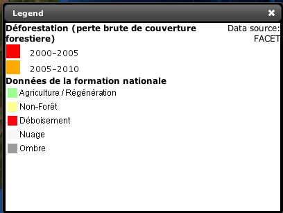
Legend
Contexts
contexts puts in relation layer objects with real elements in the User Interface - see image below. A context can cointain one or more layers.
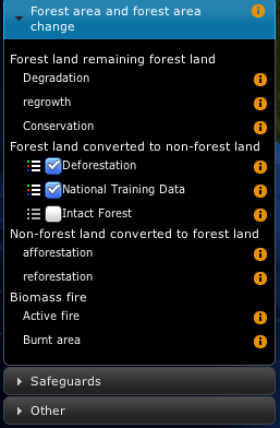
Two levels layer pane
Here is an example of the context section in the JSON file:
{
  "id": "deforestation",
  "infoFile": "deforestation_def.html",
  "label": "${deforestation}",
  "layers": ["deforestation"]
},{
  "id": "reddPlusInitiatives",
  "active": "true",
  "infoFile": "redd_plus_initiatives_def.html",
  "label": "${redd_plus_initiatives}",
  "layers": ["reddPlusInitiatives", "reddPlusInitiatives_simp"],
  "inlineLegendUrl": "/geoserver_drc/WMS?REQUEST=GetLegendGraphic&VERSION=1.0.0&FORMAT=image/png&WIDTH=20&HEIGHT=20&LAYER=unredd:redd_plus_projects&STYLE=redd_plus_initiatives&TRANSPARENT=true"
}
Optional elements are identified with a * sign.
id: the context identifier. Should be unique.label: label to be shown on the user interface - its value points to an element in the translationmessagesfile (see above) through substitution tag${...}.layers: array with references to layerid‘s in the layers section.infoFile(optional): html file with the info related to the context. It is resolved to the custom dir pathwww/loc/<language_code>/html/<infoFile>. It is loaded when clicking on the
inlineLegendUrl(optional): url of the legend image to be shown at the left of the layer name, if available (see image below). It’s only usable if the layers has a legend that fits a 20x20 pixel imageactive(optional): indicates if layer will be active when page is first loaded.
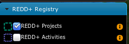
REDD registry menu
contextGroups
The contextGroups defines the tree structure (up to three levels) of the layers pane.
 "contextGroups": {
   "items":[
      {
         "group":{
            "label":"${base_layers}",
            "items":[
               { "context":"blueMarble" },
               { "context":"facetForestClassification" },
               { "context":"uclForestClassification" },
               { "context":"landsat" },
               { "context":"hillshade" }
            ]
         }
      },
      {
         "group":{
            "label":"${forest_area_and_forest_area_change}",
            "infoFile":"forest_area_and_forest_area_changes_def.html",
            "items":[
               {
                  "group":{
                     "label":"${forest_land_remaining_forest_land}",
                     "items":[
                        { "context":"degradation" },
                        { "context":"regrowth" },
                        { "context":"conservation" }
                     ]
                  }
               },
               {
                  "group":{
                     "label":"${forest_land_converted_to_non_forest}",
                     "items":[
                        { "context":"deforestation" },
                        { "context":"trainingData" },
                        { "context":"intactForest" }
                     ]
                  }
               }
            ]
         }
      }
   ]
}
It’s a recursive structure, but the parser only renders up to the second level (‘’Deforestation’’ and ‘’National Training Data’’ in the image above)
group- At the first level it defines the different expandable elements in the “accordion” layers pane (REDD+ Registry in the image above)
- At the second level (optional) it defines a grouping for the contexts
- At the last (second or third levelS) it defines the context contained in the group. Each
contextstring in theitemsarray must match one of the contexts defined earlier
label: label to be shown on the user interface - its value points to an element in the translation messages through${...}replacement syntax.